Published 2025-08-29
At Geographic Solutions, we use drone photogrammetry to turn overlapping aerial photos into accurate, measurable 3D models. For construction sites and mines across Washington and the Pacific Northwest, this means fast, defensible quantities, clear visuals, and fewer surprises.
What is Photogrammetry?
Photogrammetry is the science of extracting 3D information from 2D images. A drone flies planned paths capturing many overlapping photos. Software then:
- Detects common features between photos (tie points)
- Solves the camera positions and lens parameters (bundle adjustment)
- Reconstructs a dense 3D point cloud
- Builds surfaces and textures to produce deliverables like orthomosaics and 3D meshes
Typical outputs
- Orthomosaic (GeoTIFF): true-to-scale aerial map
- DSM/DTM: surface and bare-earth elevation models (DTM when conditions allow)
- Dense point cloud (LAS/LAZ) and 3D mesh (OBJ/PLY)
- Contours, volume reports, cut/fill maps, and as-built surfaces
Accuracy
With the right workflow—GCPs, RTK/PPK GNSS, and checkpoints—photogrammetry routinely delivers centimeter-level accuracy on exposed surfaces, suitable for engineering workflows. As with any method, dense canopy, water, or low-texture/reflective surfaces reduce reliability; in those cases we’ll adjust the plan (e.g., add control, vary altitude/angle, or recommend LiDAR).
What We Do for Construction and Mining Industries
- Cut/Fill Analysis & Maps
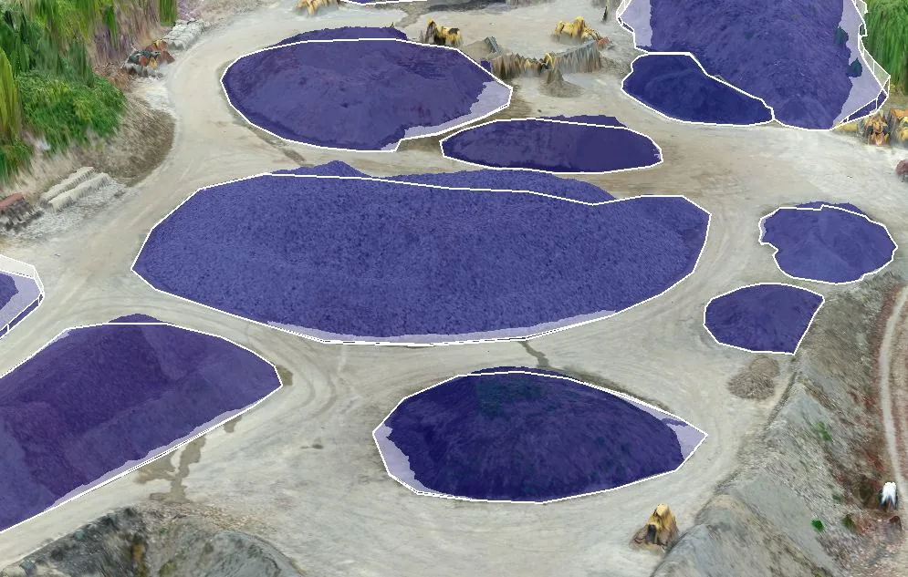
Compare current grade to design or prior surveys. Get color-coded cut/fill maps and precise quantities to plan earthwork and verify pay items. - Stockpile Volumes
Measure aggregates, soils, asphalt grindings, and topsoil with defensible, audit-ready reports. - Progress & As-Builts
Produce orthomosaics, surfaces, and linework for progress meetings, RFIs, change orders, and as-built documentation. - Machine Control & Takeoffs
Export clean surfaces/contours for CAD/Civil 3D. Use current ground to refine takeoffs and reduce over/under-run. - Claims & QA/QC Support
- Independent check on engineer quantities; visual record of site conditions to resolve disputes quickly.
What We Do for Mines & Quarries
- Pit Progression & Bench Mapping
Track advance/retreat, bench widths, haul roads, and berm compliance. - Inventory & Reconciliation
Regular stockpile volumes for month-end and year-end reconciliation. - Blast Planning/Back-Analysis
Pre- and post-blast surfaces for heave, muckpile volumes, and pattern optimization. - Slope & Highwall Monitoring
High-fidelity models to inspect discontinuities and track change (paired with appropriate safety standoff and methods). - Reclamation & Compliance
Cut/fill to design grades, contour packages, and visual documentation for submittals.
Our Process: Step-by-Step
Here’s what it looks like when Geographic Solutions performs a photogrammetry project:
- Discovery & Scope: Define goals (cut/fill to design, stockpiles, progress), accuracy targets, tolerances, deliverables, and file formats (GeoTIFF, LAS/LAZ, DXF/SHP, OBJ/PLY, etc.).
- Regulatory & Site Readiness: Confirm Part 107 ops, airspace/LAANC if needed, safety plan, site access, and coordination with your superintendent.
- Control Strategy: Plan GCPs and checkpoints (surveyed with RTK/PPK). Choose ground targets or painted marks.
- Flight Planning: Set altitude, endlap/sidelap (e.g., ~75%/65%+), camera angle (nadir + oblique if needed), and ground sampling distance to meet accuracy and feature coverage.
- Acquisition: Fly the grid(s) safely, capture images, and collect control/metadata. We add cross-grid or obliques on complex structures/steep slopes.
- Field QC: Quick on-site review of image coverage, exposure, and control visibility; refly gaps if required.
- Processing: We use software to calibrate cameras, align photos, run bundle adjustment, build dense cloud, DSM/DTM, mesh/texture, and orthomosaic. Integrate design surfaces if cut/fill is part of scope.
- Accuracy Assessment: Validate against checkpoints; compute RMSE and residuals. If needed, we tighten constraints or add local refinements.
- Analysis & Reporting: Generate stockpile volumes, cut/fill maps/quantities, contours, and as-built surfaces. Annotate assumptions (base planes, toes, breaklines) for transparency.
- Deliverables & Handover: Package GIS/CAD files (GeoTIFF, LAZ, DXF/SHP, OBJ/PLY) plus a short methods & accuracy memo so the data is defensible.
- Review Session: Walk your team through results, confirm quantities, and align on next steps.
- Monitoring (Optional): Set a recurring cadence to track progress, changes, and reconciliation over time.
Why Clients Choose Geographic Solutions
- Centimeter-level results on exposed terrain with documented accuracy checks
- Actionable outputs your field and office teams can use immediately (Civil 3D, GIS, takeoffs, and pay apps)
- Construction & mining fluency—we speak cut/fill, bid items, benches, haul roads, and reclamation
- Right tool, right job—we offer photogrammetry and LiDAR, and we’ll recommend the method that best fits your site conditions and tolerances
If you’re managing earthwork, stockpiles, pit progression, or as-builts in Washington or the broader Pacific Northwest, we can help.
Geographic Solutions delivers dependable photogrammetry 3D mapping with the formats, accuracy, and documentation your project requires.
Let’s talk about your site and deliverables.
How Geographic Solutions can help
Geographic Solutions supports aggregate operators, landowners, contractors, and investors with permitting, mapping, reserve modeling, market studies, valuation, and due diligence for pits and quarries in Washington and Oregon.